Helling in de Lochterweg | De Mortel

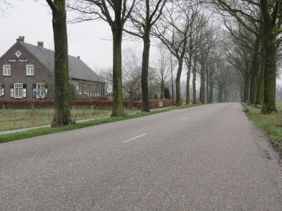
If you look from west to east across Lochter Road, you will see a slope in the road. The difference in elevation is 2 meters over a distance of 500 meters. That difference in elevation was caused by the Peelrand fault.
The Peelrand fault In the subsoil of Gemert-Bakel there are faults in the earth's crust. The Peelrand f…
If you look from west to east across Lochter Road, you will see a slope in the road. The difference in elevation is 2 meters over a distance of 500 meters. That difference in elevation was caused by the Peelrand fault.
The Peelrand fault In the subsoil of Gemert-Bakel there are faults in the earth's crust. The Peelrand fault is the most important of these. Side faults are the Breuk van Gemert, the Breuk van Gemert-zuid, the Breuk van Handel and the Breuk van Milheeze. The soil on the east side of this fault system slowly rises. This is the so-called Peelhorst. The soil on the west side is slowly descending. That is the so-called Roerdalslenk. This vertical movement averages about 0.5 mm in ten years. In the long run, this will become large height differences. Because at the same time the descending Roerdalslenk is filled up by the wind with covering sand, there are no steep slopes and the height differences are not visible everywhere. At this location, however, that height difference is visible. In the berm ditch there are two weirs close together to accommodate the difference in height in the watercourse. Besides differences in elevation, there are other phenomena by which you can recognize the location of Peelrand fault and its side faults.
The slope in the Lochterweg as a result of the Peelrand fault Two weirs are needed to accommodate the difference in elevation due to the Peelrand fault.