
Oude Handwijzer Klotterpeel
Contents
1 Old Manual in the Klotterpeel
2 Important roads through the Peel
3 Handbook
4 The adjacent Kruisberg
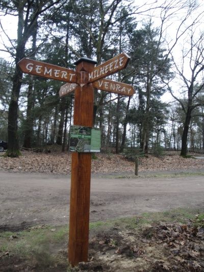
This used to be an important crossroads. Here crossed centuries-old dirt roads that made passage through the lonely Peel possible.On topographical maps from around 1850 an Old Handwijzer was already mentioned at this place.
The hand sign pointed in the direction of the road that ran from Gemert to Venray. This had been the main Peel passage for centuries. In the French era around 1811, this road was therefore called,Le grande chemin de Gemert a Venray (The great road from Gemert to Venray) Also, the hand sign indicated the direction of the road to Deurne/Milheeze and Oploo.
Back then there were no trees…
Contents
1 Old Manual in the Klotterpeel
2 Important roads through the Peel
3 Handbook
4 The adjacent Kruisberg
This used to be an important crossroads. Here crossed centuries-old dirt roads that made passage through the lonely Peel possible.On topographical maps from around 1850 an Old Handwijzer was already mentioned at this place.
The hand sign pointed in the direction of the road that ran from Gemert to Venray. This had been the main Peel passage for centuries. In the French era around 1811, this road was therefore called,Le grande chemin de Gemert a Venray (The great road from Gemert to Venray) Also, the hand sign indicated the direction of the road to Deurne/Milheeze and Oploo.
Back then there were no trees and what you saw was just an open plain of heather. Imagine: it is foggy and you are on foot or with a horse and cart. What a godsend it would be if you came across a signpost on your path pointing you in the right direction.
It was so named because the adjacent "mountain" was intersected by the road structure in the form of a cross. In the middle of the cross stood the hand sign which then disappeared around 1950.
The current hand sign was placed near the old spot in 2011 as a permanent reminder.
replica old hand sign ca 1850 with info panel topographic map ca 1850 with two old hand signs