Historical Lieshout
On the occasion of their 10th anniversary, Heemkundekring Hof van Liessent set out a cycle route. This route within the boundaries of Lieshout takes you through a richly variegated landscape and past more or less well-known places. The place where the old town hall stood, formerly Hotel Brox, the birthplace of Martinus Coppens, the famous photographer from Brabant, are some of the places you will pass by.
Locations on this route
Start point
Heuvel
5737 Lieshout
Navigate to starting point
Directions
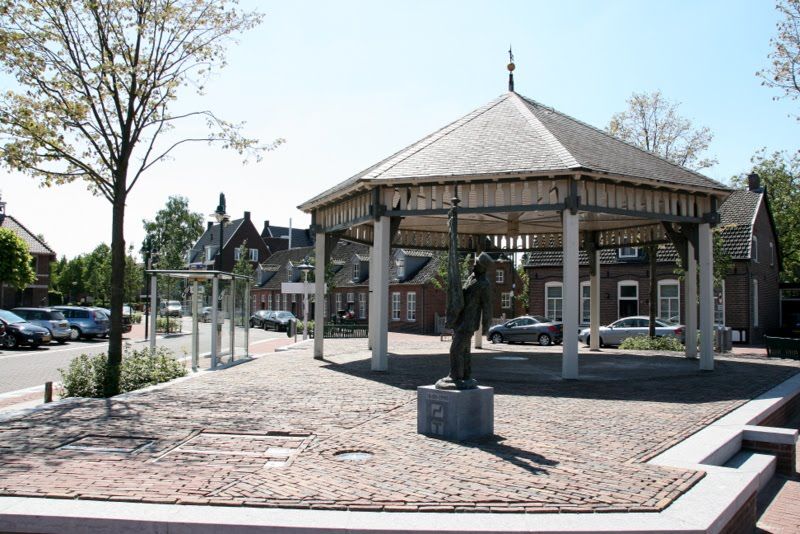
The route starts on the Heuvel. On the site of the old town hall, there are now residential flats. The Kiosk is located on the Heuvel. Bavaria Brouwerij Café used to be Hotel Brox, a building that originally dates from 1802, built by Marinus van de Ven. In 1947, the building was destroyed by fire and rebuilt. To the left of the Kerkhof path is the birthplace of Marinus Coppens, the famous photographer from Brabant. Next to it are terraced houses, which at the time contained small shops. These houses were renovated in 1990.
You are now cycling into Dorpsstraat, where the old doctor's house used to be at number 10. Later, this was Prinsen garage and now it is Prinsenhof.
The old boys school (built in 1859) stood there too. Next to it, now nos. 18 and 20, used to be the premises of the Kuster family, who had an agricultural machinery business there, which later became Staadegaard. The building has been rebuilt and there are now shops. The Kuiperstraat is named after Frenks Maas because there used to be the old Kuipershuis of Frenks.
To the left is Huize at no. 21, the house was built in 1922 by Roel Merkelbach. The house has been completely restored. Further on you see the statue de Meet on the right at the Jumbo. De Meet reminds Lieshout of the rich cycling history of the village.
On the left you see old workers houses, renovated in 1991. Now it is one house, but in the past it were two houses. The farrier Piet Siegers used to live here. Now his son lives here, also a blacksmith.
Further left was the old furniture factory of Merkelbach, known for its old Dutch furniture. There was also a small museum in the old part. The furniture factory has been converted into flats and Merkelbach moved to the industrial area De Stater. Straight ahead, you cycle on the old milk factory Landbouwers Welvaren. It opened in 1906 and closed down definitively in 1940. Later, doctor Teepen lived there.
In the bend on the right is the building where the Merkelbach arms shop used to be. Here lived Jan de Smed, Jan the old guild emperor. Jan claimed that from his house to the old church in Burg v/d Heuvelstraat there were 13 cafés, now there are only 3.
You go left into Schutstraat and keep left here. Where you see the sub camp you go left along the camp and then left into Den Houw, where there are beautiful farms.
In the big bend you keep left. In front of you is the Nieuwenhof-Noord plan. Many archaeological excavations have taken place here, with many finds.
After the new building on the right, you will see an old farmhouse on the left. This was Hoeve van der Schoot. This is still mentioned on the gate. For a long time, the Swinkels family lived here. Now it is a care farm.
The Schootsche Hoeve is one of the 9 original farms of the Abbey of Floreffe.
At the junction, turn right into Brugstraat, which is De Schoffel at the end, then keep left and follow the road until the end. You then come to the Molenstraat, turn left along Molen de Leest. The mill was built in 1900 by Mannaers, son-in-law of Dr. de Mol. In 1975, the mill was bought by the municipality and sorted out. In 1990, national monument 'De Mulder' was placed. The mill is often open for viewing. Take the first road on the right, the Havenweg.
On the corner where there is a house now, there used to be the old clog makers house of Peer Foolen. On the left-hand side of Havenweg is the mansion, originally the hunting lodge of Mr Bout. Turn left into Papenhoef, you are cycling out of this street. Turn left. You will see the old Bavaria pre-purchase office on the left, built in 1916 by Pastor Giessen. On the right you will see Bavaria Brewery. Bavaria indicates anno 1719, but they are probably older. Laurens Morrees had a beer brewery in the farm of W. Biemans in the Dorpstraat. On 30 December 1764 his daughter Brigitta married Ambrosius Swinkels, and from that moment the name Swinkels was connected to the brewery. The Bavaria complex started in 1924 and in the years that followed, it grew to what it is today. The new brewery was built by the Gebr. v/d Heuvel for 2710 guilders, this is the building that now houses Brouwhuis 1. At this moment, the seventh generation of Swinkels is working there. The brewery, which has several breweries under the name Swinkels. However, it still uses the Bavaria beer brand.
Keep to the left and you will again approach the centre of the village and see the Binderen Gate. Behind this gate you will see the church, which was inaugurated in 1962. Huize Ribbius used to stand here; Mr Ribbius was the former secretary of the municipality. Cycle right down Ribbiusstraat to Provincialeweg, turn right at the roundabout, keep right towards the bridge. Across the bridge, turn right onto the cycle path along the canal, dug in 1917-1918. The original bridges were destroyed at 15.00 on 10 May 1940 and the new bridges were only built in 1969. Along the canal, between the two bridges, used to be the birthplace of Martinus Swinkels (Tinus the verger a well known photographer from Lieshout). This house was also the birthplace of the famous cyclist Piet Damen. Later the Timmers family lived there.
During the digging of the canal, old parts were found, probably dating from Roman times, a Roman watchtower. After the next bridge you turn left and cross the main road. After the big bend there is a farm on your left. This is where the origin of Lieshout lies. This is where the Heemkundekring got its name 't Hof van Liessent.
The first mention of Lieshout is from 1194, the lord of Lieshout Boudewijn became a Premonstratensian Monk and donated Lieshout and all his other possessions to the Abbey of Floreffe. At the farm on the left, you can still see part of the monastery church behind the house. Underneath are the old cross vaults. In front of the farm, where there is now meadow, and where you can see a large hump, there used to be a graveyard belonging to the church. The sign shows a picture of the church that was built there after the monastery church. In 1800, the church was badly damaged during a storm, only the tower was still in good condition. It was broken down and rebuilt in the Burg. v/d Heuvelstraat. You go back across the main road and then turn left into Deense Hoek. The wooden houses on the right were built before the digging of the canal and were used as offices.
Later Lieshouts jersey company was called Litrofa. In these 2 houses the fam. van Venrooij and de Leest lived for a long time. Where the road ends you turn right into the Achterbosch. Here are several farms built of bricks baked in the field kiln. This was located left behind the lock keeper's house. The farm at the left, nr 11, is one of the oldest farms in Lieshout and was built between 1785 and 1791. The outside of the farmhouse used to be plastered. This was actually an image-defining building and should therefore not have been. Before you pass the sluice you see on your left the Ruweeuwsels, a beautiful nature reserve of about 16 ha, where you can make lovely walks. After crossing the locks you pass the Helena Hoeve. You enter the Sluisweg on the Soneseweg, on the left corner you see the water station of the W.O.B. Here you go left on the Soneseweg until the first road on the right, there you enter the Broek. The Broek soil that you see here was reclaimed in 1913.
The Broekwal fair used to be held here. Toon Boudewijns (Toon den Tus) had an inn here, where people drank and fought at the fair. You cycle through the Broek until you reach Knapersven. Keep following this until you see the Plevierstraat on the left. Enter this street and keep left until the end of the road. Then turn left into Meerven, 2nd dirt road. At the end of the dirt road you will see in front of you the beautiful Torreven, worth to see.
From the dirt road you came from turn right until you reach the Rooijseweg, turn right here. Take the first left, before the crucifix, turn right into the Tuindersweg. There you see the Totem pole, which was donated by the Mariahout emigrants from Canada. Turn right into Pionierse4g and right again into Zr. Persoonsstraat. You cycle along Oranjeplein where there is a playground for the youth. You end up in Mariastraat where you turn left. On the right you will see the Open Air Theatre with the Procession Park. The church was built in 1933 by Pastor van Eijndhoven. This pastor had a Lourdes grotto built here, which was very popular for years. In 1982, the grotto was rebuilt. You are now cycling towards Ginderdoor, on the right you can see the Martens company, which used to be an agricultural machinery business that the family had for more than a century. This used to be the location of the inn 'De Reizende Man', which was very well-known in those days. You are now on Ginderdoor, after the large bend in the road before farm no. 37, there used to be a chapel, which was demolished in 1815. The oldest mention of the chapel is 1485. With the demolition of the chapel, the materials were used for the field guard house, which stood at the corner of Dorpsstraat / Vogelenzang. This has now also been demolished. The name Ginderdoor already appears in a carter of 12-01-1311 of Duke John of Brabant. Then you turn right into Broeksteeg, where you turn left into a sandy road also called Broeksteeg. Before you turn left, you see a large mountain on your right. This used to be a dump for waste. The area was also called Keelgras in 1246. On the left you see the nature reserve Moorsel. The Moorsel is 11 hectares and divided over 6 fields. In May and June, thousands of flesh-coloured orchids grow here. A very rare plant that only grows in a few places in the netherlands. The Moorselen has a middle path that is accessible via a gate at the paved part of the Broeksteeg. The fields can only be entered with an IVN guide.
The first path on the left, over the Donkervootseloop, leads to the Mill. This mill was built in 1819 by Antoon Swinkels. In 1974, it was bought by the municipality and restored. You now enter the Provincialeweg where you turn right into the Dorpstraat. After 100 metres, turn left onto the cycle path and follow this path until you reach Baverdestraat. Along the Provincialeweg is a beautifully renovated longhouse. In Baverdestraat take the 2nd left into Nieuwstraat. In this street, the first houses were built by the municipality after the war. Cycle out of Nieuwstaat and turn right back to Heuvel, the starting point. Here, you can quench your thirst at the village pump, which was built by the Guild and sometimes serves beer on special occasions.