Archeologische opgraving: Neerakker, Bakel

Following the construction of a new residential area south of Bakel, archaeological research was carried out. Large parts of two settlements were found on one site. The first settlement dates from the Late Iron Age, around 900 BC. The second settlement dates from the Late Middle Ages, around the 12th to 13th century. This second settlement consisted of five courtyards with main buildings and several barns and outbuildings. There was a court from which taxes were collected. Loam was also mined on a very large scale in this village.
During the archaeological survey at Bakel, Neerakker, …
Following the construction of a new residential area south of Bakel, archaeological research was carried out. Large parts of two settlements were found on one site. The first settlement dates from the Late Iron Age, around 900 BC. The second settlement dates from the Late Middle Ages, around the 12th to 13th century. This second settlement consisted of five courtyards with main buildings and several barns and outbuildings. There was a court from which taxes were collected. Loam was also mined on a very large scale in this village.
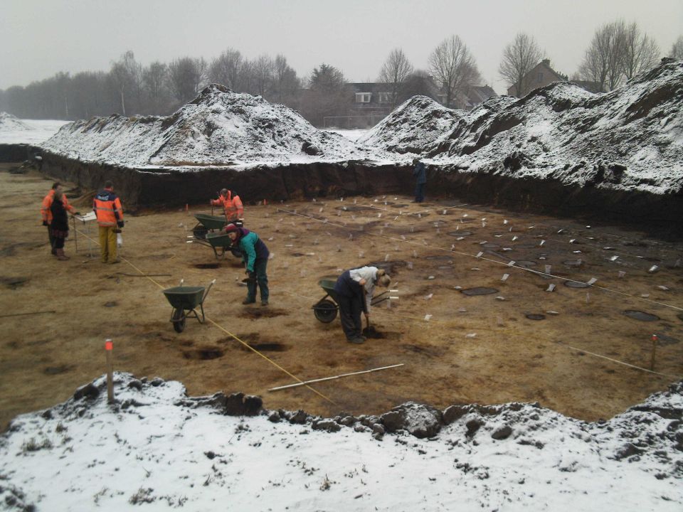
During the archaeological survey at Bakel, Neerakker, a large number of ground tracks were found, as well as archaeological find material in the form of pottery shards, natural and flint, fragments of animal bone material and some other material categories. Most unusual is the quantity and quality of the ground tracks. From the more than 5,400 traces that could be documented in the field, floor plans of houses, barns and other outbuildings were reconstructed during elaboration. With the help of house typologies and pottery typologies, it was already possible to state during the fieldwork that there was habitation in the Iron Age and in the Full or Late Middle Ages. Meanwhile, dendrochronological and 14C research has taken place. The dates can thus be refined to Early Iron Age, roughly around 800 BC, and the Late Middle Ages, 12th-13th century. Two houses, five barns, one storey and two cattle corrals date back to the Iron Age. There are also several waste pits from this period. One house and one barn were sampled for phosphate analysis. The analysis for the barn has now taken place and it appears that this barn was not used to house livestock. The analysis results for the house are expected by the end of February 2010. The phosphate analysis is eagerly awaited, as this Iron Age house type is traditionally considered to be a dwelling-stable house. This assumption is now being tested for the first time in Dutch archaeology and the phosphate analysis is expected to give a definitive answer on the actual function and spatial layout of this house type.
The vast majority of structures date back to the Late Middle Ages. It was possible to reconstruct a large part of a medieval settlement. There are five different courtyards, consisting of a house, one or more barns, smaller outbuildings and a well. These yards are located along through roads (cart paths) and sometimes bordered by plot ditches.
The westernmost yard has a special character. The yard is moated, has an impressive driveway and probably access to a waterway. Indeed, transport by water was crucial in the Middle Ages because it was possible all year round, unlike land transport. The buildings in this yard are also special. There are initially three occupation phases, each characterised by having an exceptionally large farmhouse and barn. In addition, each phase contains a well and sometimes a single small outbuilding. The inhabitants of this yard did not provide for themselves through farming and animal husbandry. Thus, there is evidence of an elite. This can be deduced from the results of botanical research (macro remains and pollen analysis) in particular, as well as from the size of the buildings and the farmyard layout. The large barns served to collect and temporarily store taxes in kind. Archival research seems to indicate that there may have been a court owned by monastery Echternach, founded in 1161. This would mean that taxes were collected in kind on behalf of this monastery. However, archival research is very time-consuming and not yet complete. The dating of the pottery is consistent with an initial date in the mid-12th century.
The inhabitants of this main estate probably determined the infrastructure and land use of a much larger area. The research area is dominated by a triangular plot of probably about 3 ha, within which Brabant clay was extracted. This main farmstead and the remaining four farmsteads are located around this loam extraction plot. One solitary house is also located outside this area. The loam extraction plot is bordered by ditches and at least one cart path can be reconstructed here. There is concrete evidence of ironworking in one of the farmyards. Another