Ommels Ommetje
The brochures with route and text of Het Ommels Ommetje are available in café "Ons Jantje" on the Kluisstraat or you can print them out. You can also start from Landgoed Kraneven. This Ommetje is a short walk through the center of Ommel. The distance is only 3 kilometers. You can also opt for a longer route with a detour through nature. Then its length is 5 km. You make the choice during the route. During the walk we will tell you about the history of our village. From the past to the present. The route map is in the back. Have fun!
Locations on this route
Start point
Café Ons Jantje
Kluisstraat 1
5724 AD Ommel
Navigate to starting point
Church of the Presentation of the Holy Virgin
Onze Lieve Vrouw Presentatie kerkMarialaan 16
5724 AB Ommel
Church of the Presentation of the Holy Virgin
Church of the Presentation of the Holy Virgin
Onze Lieve Vrouw Presentatie kerk
Marialaan 16
5724 AB Ommel
Directions
The route starts opposite the café from the information board, junction 46 of the De Peel cycle route network.
1; The old Chapel; An ivory statue of the Virgin Mary was found in Ommel around 1400. Many people from the area came to pray at the statue. Residents had placed it in a wooden box on a pole. A better place was desired, but also entailed costs. Jan van Haven, a skipper at sea, was in distress and prayed for help. When his prayers were answered he promised to build a chapel in Ommel. And so it happened. On the site of the starting point of the walking route, on the current square, the Roman Catholic chapel below was consecrated in 1444. The statue of the Virgin Mary was given a prominent place in this.
The chapel was renovated several times and in 1900 grew into a parish church with a tower. The church was so destroyed in World War II that it had to be demolished further. The current modern church was inaugurated in 1963. On your route you will pass here later and there is the possibility to admire the statue of the Virgin Mary.
Follow your route along the Jeu de Boules track to the other side of the square. Carefully cross over to the artwork in the shape of a tree.
2; A special work of art. "The Tree Fountain". This artwork was made by the late Charles Vergouwen from Tilburg. It's a tree of life. Primary school children have had their hands made prints that form the leaves at the ends of the branches. The solidarity and connection with Ommel are rooted in the earth. The running water is the lifeblood of this small community. Then turn slightly to the right and continue on the parallel road of the Kloosterstraat. On your left is a lawn with trees.
3; For several centuries, the nunnery 'Maria Schoot' stood at this lawn. Where you walk was the old road between the houses on the right and the 80 meter long monastery on the left of the road. The monastery was founded in 1539 by Marieke van de Goor. The last remaining part of the monastery was destroyed in 1922 by a fierce fire that left no less than 6 families homeless. This part of the monastery was built in 1626. At the time of the fire in 1922, the monastery was inhabited by the family of Lambert Berkvens and the family of Antonius van Bussel. It burned to the ground. Continue route.
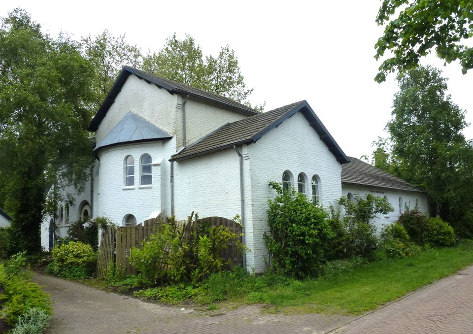
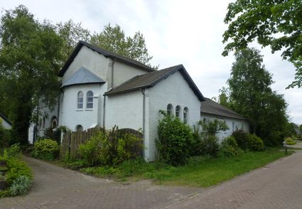
4; A little further on you will see a white church on your right. Between 1945 and 1963, this white building served as a church. This emergency church used to be a warehouse of the Boerenbond. It was built in 1925. During the war, the old church was shot to such an extent that it was no longer worthwhile to rebuild it. With the chipped stones of the old church, the farmers' association building was transformed into this beautiful emergency church. It is now a private house and you can stay in one of the bed & breakfast rooms. Cross the road opposite the church to the Hogeweg. This road used to be the main road to the adjacent village of Vlierden.
5; On the left you will see the cemetery of Ommel. The first graveyard was at the old chapel. The second was on the Kluisstraat and here we find the current
cemetery. When the old church of Ommel was demolished after the war, three graves were found under the floor. One facing the altar and 2 facing the other way. This was probably the first rector of the monastery and her 2 foundresses. They were reburied here. We continue on the Hogeweg. Immediately after the bend you have to make a choice for the long or short route.
Those who are not afraid of a dirt road and a piece of nature can choose the extended route from here. Continue reading at A---.
The short route goes straight on after the bend. At the end of the road turn left and immediately right again into the footpath. At the end of the footpath, go straight into Pastoor Vogelsstraat. At the end of the road turn left into the Kluisstraat. Read more at B---.
A---After the bend at the cemetery, turn right and follow 'de Loo'. Turn right at the sharp bend onto the dirt road.
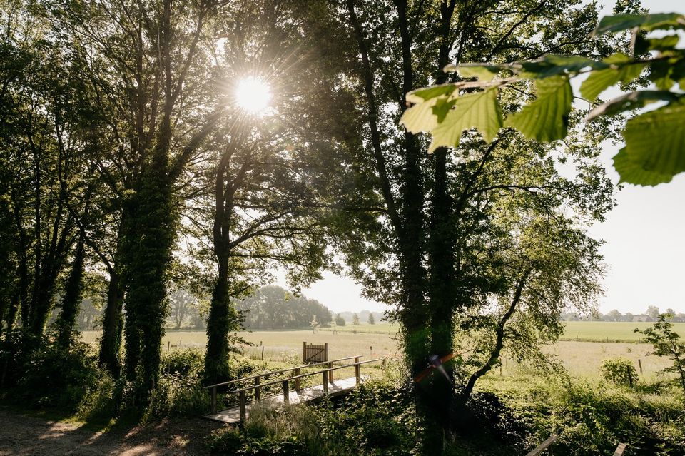
6; Fields 'the high Loo'. These high fields have been known as the high Loo for hundreds of years. It is possible that the Village of Ommel partly owes its name to this. Ommel was sometimes also written in archives as Ommelo, which means around forest. Turn right at the first folding gate. We have arrived here at the Kraneven estate.
7; Cranes. In earlier times there were several fens on the Oostappense heath. The largest were the 'Scheefven' to the south and the 'Kraneven' to the north. The first fen was excavated for sand extraction for the newly constructed E3 or A67. After that it became a recreational lake. The 'Kraneven' turned into a campsite and currently into an estate. The paths with walk-through gates on which you are now walking all belong to this Estate. At the end of this path, follow the bend to the left. Further on at the fork keep left. At the end of the path turn left and at the next fork keep left again. Then straight ahead until the first passage
gate on the right. Enter the forest through 'Heksenpaadje'.
8; the Witch's Path. This short winding path used to be much longer. No one knows why it is called that way. We do know that schoolchildren and churchgoers from the hamlet of Oostappen used to walk through here to Ommel. The name was already used then. We also know that at the beginning of the last century, there was one
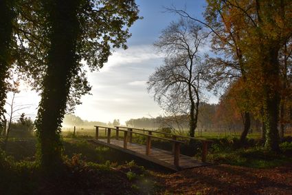
so-called witch lived on Oostappen. Possibly the nickname 'Mie the witch' had more to do with appearance or grooming than anything else. At the end of the Heksenpaadje we turn left. A little further on you will see restaurant 'de Hoge Loo' of the Kraneven estate on your right. Here you can enjoy a cup of coffee when open. Opposite the restaurant, continue the route over the bridge on the left. Then turn right. Follow the path along the fields. At a large iron gate, follow the path to the left. Then turn right at the end at the passage gate in the direction of Ommel. At the paved road, walk straight ahead. In the bend of the Kluisstraat turn left.
B---
9; At Kluisstraat no. 15 you will see the 'Mariahofke'. This used to be the kindergarten. This building is now occupied. Turn right immediately after this building into the school path. At the end of this path turn left, around the current primary school, into the Dionysiusstraat.
10; Past school and Maria chapel; Ommel's first primary school started in 1885 on almost the same spot. The chapel on the right side of the road was called 'Our Mother' by the founder, Pastor Vogels. It was an ode to his mother with probably a big nod to 'mother Maria van Ommel'. The main entrance of the old school was directly opposite this chapel. At the end of the road we cross over to the church square.
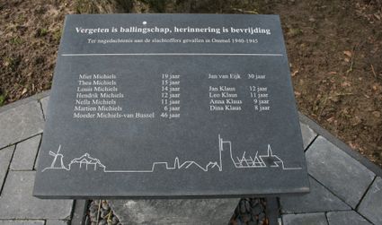
11; War memorial outside the church.
Immediately to the left of the church square, on the street side, all Ommel victims of the Second World War are named in a small memorial.
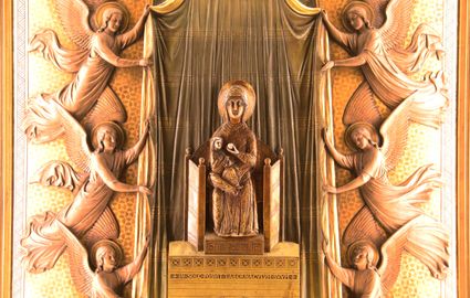
12; The statue of Mary in the church.
In the front left of the church is the Marian throne. In the middle of a work of art, the ivory statue of the Virgin Mary can be viewed, which was made somewhere between the years 1000 and 1200. A Byzantine figurine, probably made in present-day Istanbul. It may have come to Brabant with the crusades. In Ommel it has provided many pilgrims for more than 600 years who still come to the church every day for a moment of peace and reflection. The many burning candles bear witness to this. After you come out of the church again, we turn left across the church square, before the bell tower through to the adjacent procession park.
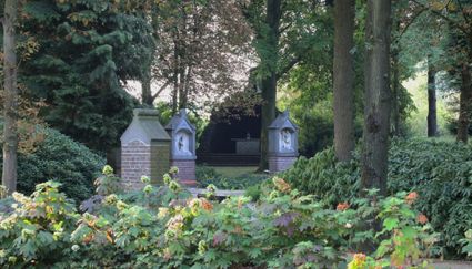
13; Processional park 'Mariaoord'.
This processional park was established in 1914 for the many pilgrims who came to Ommel. Here one could pray the Stations of the Cross with many people at the same time or listen to the sermon of a clergyman. The 14 Stations of the Cross are depicted in small chapels and are located in an outer ring in the park. The names of the donors of the stations are all in the side. An inner ring was also added in 1932. These are 6 chapels with unique sandstone scenes that depict the history of the miracle statue of Mary in Ommel. At a later stage, the Maria Grotto was also built after the example of Lourdes. From here there were
sermons and open-air masses. Especially in the month of May - Mariamonth - these outdoor masses still take place. As well as processions of solemn praise. These now take place at the rear of the church. The so-called outer church.
14; The white tram station.
This tram station used to be diagonally opposite the entrance to the park, from where many pilgrims traveled to the procession park and to the church. Often also in an organized context. The Ommel fanfare regularly collected the groups and accompanied them musically and in slow procession to the park or church. The route runs through the park behind the church. Then follow the road to the right, from the church to the Jan van Havenstraat. Here you turn right. Keep left at the fork. Immediately after the fork you will see another war memorial on the left side of the road.
15; War memorial.
This monument has been erected for the victims who were in a makeshift air raid shelter opposite this monument where a grenade hit. 10 Children from 2 families were killed. The mother who lost 6 of her children in one fell swoop later died of grief, it is said. This drama took place in a fierce battle during Operation Market Garden. In the center of Ommel 75% of all houses were shot to pieces. From here we turn around again and walk back to the end of this street.
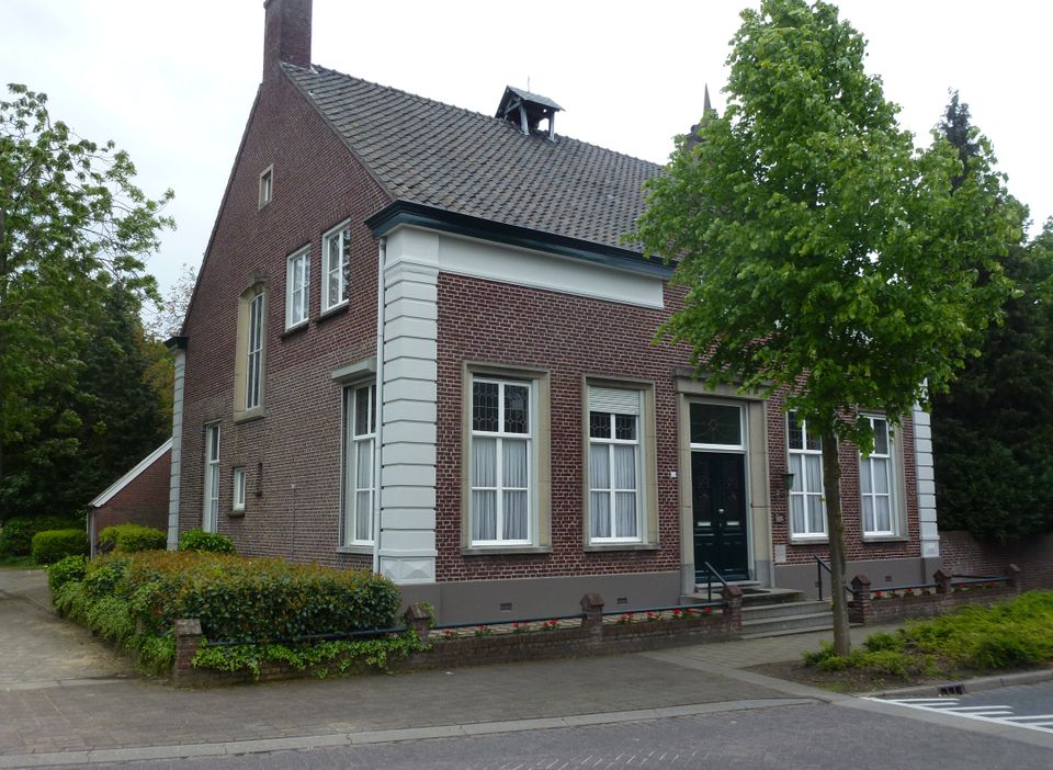
16; Presbytery.
Just before the intersection, the parsonage is on the left. When Ommel became an independent parish in 1882, a pastor's house had to be built, of course. The building was severely damaged in World War II, but was rebuilt and still serves as a parsonage. From here cross the road to get to the starting point.