Hiking the Beuven route in Someren
The Beuvenroute starts on the edge of Lierop in the hamlet of Moorsel near the parking lot of Boscafe Pastoorke Van Moorsel. Follow the Beuven…
The Beuvenroute starts on the edge of Lierop in the hamlet of Moorsel near the parking lot of Boscafe Pastoorke Van Moorsel. Follow the Beuvenroute signs. There is a short route (5 km) and a long route (10 km). The short route goes from the starting point towards the Beuven and runs back to the starting point via the Starven. The long route (10 km) also goes towards the Beuven but goes in a southerly direction along the Grafven to the Hoenderboompaal. The route then runs in a westerly direction over a bat bridge and then along the Peelrijt. At the Beuvenlaan, the route heads north towards Moorsel. The route here runs through the heath and over drifting sand towards the Starven. This route can also be combined with the Witven route or the Bontven route. The free brochure of this Beuven walking route with a map and description of all objects is available at VVV Someren, or click on the button below; "View route in PDF"
Locations on this route
Start point
gehucht Moorsel Lierop
Moorsel
5715PX Lierop
Navigate to starting point
Boscafé van Moorsel Groupaccommodation and Woodcafe and B&B
Boscafé van MoorselMoorsel 1
5715 PX Lierop
Boscafé van Moorsel Groupaccommodation and Woodcafe and B&B
Boscafé van Moorsel Groupaccommodation and Woodcafe and B&B
Boscafé van Moorsel
Moorsel 1
5715 PX Lierop
Directions
BEUVEN ROUTE
Start; The route starts on the edge of Lierop in the hamlet of Moorsel near the parking lot of Boscafé Pastoorke Van Moorsel. Follow the signs for the Beuvenroute. There is a short route (5 km) and a long route (10 km)
Description; The short route (5 km) goes from the starting point towards the Beuven and goes back to the starting point via the Dennenlust hiding camp. The long route (10 km) also goes towards Beuven and the hiding camp Dennenlust, but also goes along the Vleutloop and towards nature reserve Sang en Goorkens.
Neighborhood Moorsel; Moorsel originated as a reclamation in the 12th century. Over time, the heathland has been transformed into an agricultural and residential area. At the time, the reclamation was completely enclosed by an earthen wall with dense vegetation. Within this wall was the Moorsel farm with various outbuildings, a large arable area and next to it a swamp forest. This is where the Vleutloop originates. Peat or nut was present in this wet part. Moorsel owes its name to; a cleared forest near the moor. The Moorsel farm was split into 2 farms in 1698. In 1776 a 3rd farm was built. In the 19th century Moorsel was further divided into 5 farms. All farms are located together around the site of the medieval farm.
The Forest Area near Moorsel and Hideout Camp; This vast forest area is characterized by the great variety of forest species at a relatively short distance from each other. The area is home to a few smaller fens, with even a typical pingo ruin. A pingo ruin is the remnant of a frost mound, created by an ice core under the earth's surface that gradually grows and thus lifts the earth. The remnants (brick oven) of the Dennenlust hiding camp built in 1943 are located in the forest area near Moorsel. During the liberation on September 21, 1944, thirty Dutch people in hiding stayed there. Dennenlust also offered temporary shelter to fifteen stranded Allied pilots. Shortly before the liberation, the people in hiding took part in partisan actions in which the American pilot Frank Doucette was killed.
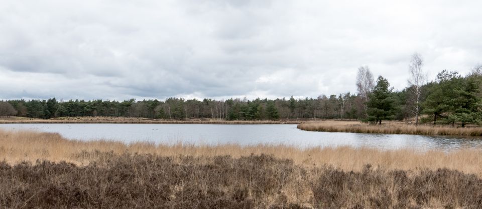
The Strabrechtse heide with the Beuven; After the forest, the walk gives a beautiful view of the Strabrechtse Heide with the Beuven. The Strabrechtse Heide and Lieropse Heide form a nature reserve of 1,850 hectares. At first glance it looks like an immense plain of only shrubs and heather, but nothing could be further from the truth. Special plants such as the water spoon and the carnivorous sundew grow around the fens. Get down on your knees to admire these and other beautiful bloomers. There is a good chance that you will also see one of the dragonfly species, a moor frog or maybe even a natterjack toad. The heath was traditionally used for grazing sheep. Sods were also cut that were used in the stables. For centuries, the manure from these stables was used on the land. With the invention of fertilizer, the agricultural system changed. Large areas of heathland were reclaimed for agriculture or forestry. To maintain the heathland, management is necessary via sod or grazing. A visit to the heather is worthwhile at any time of the year, but the most beautiful thing is when the heather flowers in August. The Beuven is the largest fen in the Netherlands and is known for its rich birdlife and is also famous for its special vegetation. The fen is fed by the Peelrijt and has a discharge via the Witte Loop to the Kleine Dommel. From the bird hide you have a good overview of the most beautiful point of the fen. but the most beautiful thing is when the heather blooms in August. The Beuven is the largest fen in the Netherlands and is known for its rich birdlife and is also famous for its special vegetation. The fen is fed by the Peelrijt and has a discharge via the Witte Loop to the Kleine Dommel. From the bird hide you have a good overview of the most beautiful point of the fen. but the most beautiful thing is when the heather blooms in August. The Beuven is the largest fen in the Netherlands and is known for its rich birdlife and is also famous for its special vegetation. The fen is fed by the Peelrijt and has a discharge via the Witte Loop to the Kleine Dommel. From the bird hide you have a good overview of the most beautiful point of the fen.
Scottish Highlanders now graze in part of this area. This breed of cattle is very suitable for year-round use in nature reserves as a large grazer. They require little care. Highlanders also feed on plants that many other bovine species ignore, and their long hair allows them to stay outside during the winter months.
The Vleutloop and the Sang en Goorkens nature reserve; The Vleutloop originates at Moorsel. At the start of the route, this is still a very small stream, which even largely dries up in summer. More to the north, past the A67, the watercourse gradually widens. North of the Sang en Goorkens nature reserve, the Vleutloop meets the Goorloop. The Goorloop flows further north from here, straight through Helmond and eventually flows into the Aa at Beek en Donk. Due to its location, the Vleutloop is suitable for creating an ecological connecting zone between the Sang and Goorkens nature reserves and the Strabrechtse Heide for water-bound plants and animals. In 2017, the Aa en Maas water board and the municipality of Someren established two nature reserves along the Vleutloop that provide habitat for various plants and animals.
The Vleutloop has partly been relocated and various landscape elements have been added, such as gentle banks and wooded banks with trees and shrubs. This provides habitat for thickets, amphibians and riparian plants. The intermediate grassland will gradually develop into a grassland rich in herbs and fauna. Sang en Goorkens is a valuable nature reserve of approximately 140 hectares. The area has traditionally had special natural values that depend on groundwater (seepage). The Aa en Maas water board, the municipality of Geldrop-Mierlo and Staatsbosbeheer have taken all kinds of measures to preserve, restore and experience nature in Sang en Goorkens. There are many rare plants and animals, such as various orchids, but also, for example, the large buttercup, small kingfisher butterfly, lesser spotted woodpecker and grasshopper.