There are 27 routes found for "Mariahout ponds"
Routes
1 to 24 of 27 results
-
The Laarbeek trail - Stage 4 (of 5)
The Laarbeek trail - Stage 4 (of 5)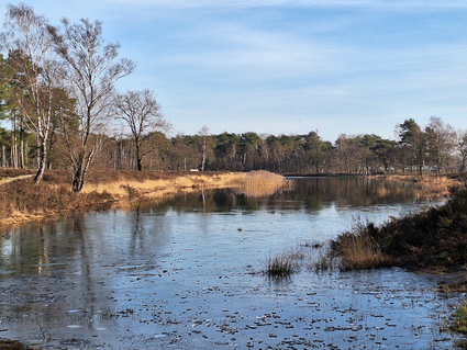
The fourth stage (15 km) of the Laarbeekpad, a long multi-day hike across the territory of the mu...
(13 km) -
Ommetje Oost - Mariahout
Ommetje Oost - Mariahout
This walk is characterised by a small-scale landscape where agriculture and forestry predominate.
(5.8 km) -
Walking routes north-east of Mariahout
Walking routes north-east of Mariahout
Northeast of Mariahout a number of beautiful walking routes are marked.
(3 km) -
Route along municipal ponds Beek en Donk
Route along municipal ponds Beek en Donk
A beautiful walking route that takes you past three municipal ponds, among other things.
(3.3 km) -
Hiking trails southwest of Mariahout
Hiking trails southwest of Mariahout
To the south-west of Mariahout, a number of beautiful walking routes have been marked out.
(3.5 km) -
Historical route - Mariahout Pioneer Village
Historical route - Mariahout Pioneer Village
This route runs through the centre of Mariahout. There are 18 QR codes on 18 signs that lead the...
(2.5 km) -
Ommetje Zuid - Mariahout
Ommetje Zuid - Mariahout
Characteristic are the small-scale elements such as pollard-willows and small wooded banks in a m...
(5.3 km) -
Round Laarbeek
Round Laarbeek
A route through beautiful Laarbeek. Along the B&B's and catering establishments.
(39 km) -
Pond route Beek en Donk
Pond route Beek en Donk
Beautiful walking route through Beek en Donk, taking you past five municipal ponds.
(5 km) -
The Laarbeek trail - Stage 3 (of 5)
The Laarbeek trail - Stage 3 (of 5)
The third stage (16 km) of the Laarbeekpad, a long multi-day hike across the territory of the mun...
(16 km) -
Janmiekesroute
Janmiekesroute
The Janmiekes route leads through a varied landscape on the border of Mariahout and Beek en Donk.
(4.8 km) -
MTBroute Mariahout
MTBroute Mariahout
It is a beautiful and varied route that consists of single tracks, forest land and natural paths.
(9.9 km) -
Ommetje West Mariahout
Ommetje West Mariahout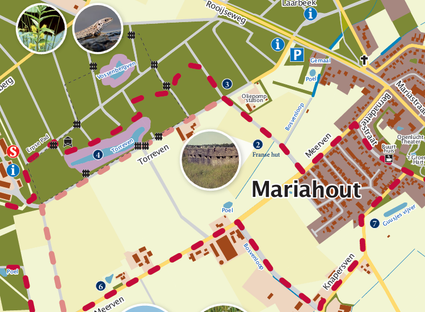
Walk through woods, meadows and thickets for numerous birds.
(5 km) -
't Geregt
't Geregt
Adjacent to Mariahout lies 't Geregt/Lijnt (Meijerijstad)
(5 km) -
Geocache Vogelnatuurpad
Geocache Vogelnatuurpad
The bird nature trail is located in the immediate vicinity of the town hall. This beautiful park...
(4 km) -
Bruggen- en kanalenroute
Bruggen- en kanalenroute
Cycling along canals and through villages. A 40 km route, past the Mariacave in Mariahout, variou...
(38.9 km) -
Torrevenroute
Torrevenroute
The Torreven route runs around and passes the Torreven, Vossenbergven and the Haverven (near the...
(6.5 km) -
Death Valley De Peel - Liberation Route Laarbeek
Death Valley De Peel - Liberation Route Laarbeek
The signposted cycle route leads past commemorative monuments and events that that took place in...
(28 km) -
Fietsen door het Brabantse land
Fietsen door het Brabantse land
A route through varied landscape and characteristic villages.
(45.2 km) -
Door de Meijerij
Door de Meijerij
This route goes through Schijndel, Mariahout and Gemert.
(69.3 km) -
Geocache Ommetje Oost - Mariahout
Geocache Ommetje Oost - Mariahout
Ommetje Oost shows mainly small-scale landscape in the form of arable farming and forest. On the...
(5 km) -
D'n Erpse Pad
D'n Erpse Pad
Hiking route that runs across a central Brabant sand ridge.
(6 km) -
The Laarbeek trail - Stage 5 (of 5)
The Laarbeek trail - Stage 5 (of 5)
The fifth stage (17 km) of the Laarbeekpad, a long multi-day hike across the territory of the mun...
(17 km) -
The Laarbeek trail - Stage 1 (of 5)
The Laarbeek trail - Stage 1 (of 5)
The first stage (15 km) of the Laarbeekpad, a long multi-day hike across the territory of the mun...
(15 km)
- Current page 1
- Go to page 2
- Go to the next page